Travel: Atlas Mt.-Ifrane, Midelt, Tafilalt, Erfoud. Morocco 4/14/2023
- Apr 14, 2023
- 10 min read
Updated: Jul 7, 2023
Continuation of a guided group trip. which started on:
4/10 - From Tangier to Casablanca (part 1)
4/11 -Rabat- Imperial capital (part 2)
4/12/Meknez - Imperial Capital (part 3)
4/13 Fez -1st Imperial Capital (part 4)

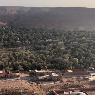
Traveling from Fez toward Ifrane


The long travel day from Fez which started at 8:00 am, dragged initially, through extended narrow flat plain corridor between the Rif mountains and Middle Atlas mountains, about 120 km east of Fez
The landscape is covered at times by Olive groves, Apple orchards and vineyards, before hitting the elevation of the northernmost Mid Atlas Mt. Range, which is the second
highest of three main Atlas Mountains chains of Morocco..


Olive trees were imported by the Greeks, the vineyards were brought by the Romans, and later the Oaks and after Cyprus and Eucalyptus trees brought by additional invaders.
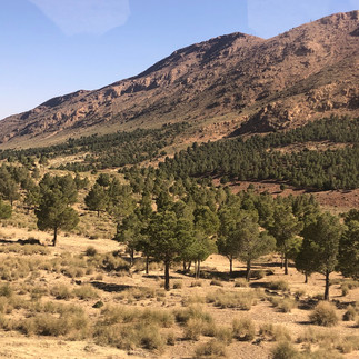
With the extended elevation of the mountainous range the landscape changed into large Pine groves .
After passing Isamar Condor - a small town on the way, originally Berber place which became a French vacation destination, the bus unloaded the group at Ifrane


Ifrane - Cave

Located at an elevation of 1,665 m, this charming mountainous town of about 30,000 inhabitants, was established in 1928 as a "hill station" or a colonial post type of administrative settlement. by the French administration, on land expropriated from the local inhabitants,. during the protectorate era (1918- 56 thanks to its Alpine climate.
Initial Cave dwellings hollowed out of the limestone valley wall, were already established here in the 16c. Only in the last 70 years or so have its inhabitants built houses above ground.T he caves which now lie under these houses, are still used as mangers for animals and for storage.
Later as a resort town which was set by the French, high up in the snowy in winter mountains, Ifrane served so the Europeans could find relief also from the summer heat of the interior plains of Morocco. as well as a popular altitude training destination.

The town was initially planned according to the "garden city" model of urban design. with chalet-type summer homes in the Alpine style, laid out among gardens and curving tree-lined streets.

A Royal Palace (one out of 14th in Morocco) was also built for Sultan Muhammad b. Yûsuf.

Morocco facilitated secret talks (p15) between Israel and the Palestinians at the July 22nd 1986th Fes conference with Rafi Edri and Prime Minister Shimon Peres, at the Ifrane royal Palace .
The town's first public buildings consisted of a post office and a Roman Catholic church. and later a Police Academy and the new police Commissariat, also had a penitentiary which served as a POW camp during World War II.
The Lion Sculpture Mystery

The penitentiary, which no longer exists, ,had been redeveloped as a summer camp for the Ministry of Justice.
But when it served as a Prisoner of War camp during World War II. a popular version story of the origin of Ifrane's lion sculpture involves an Italian inmate of this prison sculpting the lion out of an outcrop of limestone;
Another version to the story of the Ifrane’s landmark stone lion, which sits on a patch of grass near the Hôtel Chamonix. tells that it was carved by a German soldier during WWII, when Ifrane was used briefly as a prisoner-of-war camp, in exchange for the prisoner's freedom – or so the story goes – and commemorates the last wild Atlas lion, which was shot near here in the early 1920s
However, both stories are doubtful, as the lion dates from at least 1936 thus predating World War II.(1942)
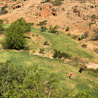
Strolling through the "Garden City" Now a days this "garden city". is an "imperial city", a mountain resort, a provincial administrative center, and a college town.

Strolling in one of Ifran's English/French landscaped gardens, consisting of a small pond imitating nature, provided its local frogs an opportunity to quack a welcoming concert for us
This most enjoyable strolling break, cut the long long.. bus drive, planned for the day.
The Pond, trees and birds at the Park.


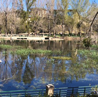


The Frog in the Pond


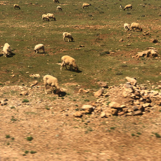
The continued bus ride passed by the small remote Timahdite village, which sits at an altitude of 1,800m on the Middle Atlas Mountains, and which was surrounded by lush forests .
Its nomadic Amazigh tribes rely on sheep that graze . .But as winter sets in, they are gradually cut off from the world.
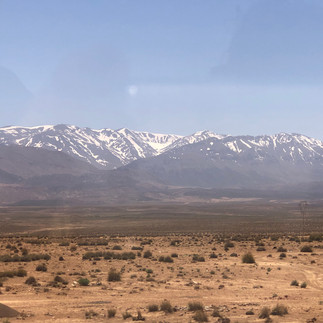
Snowy mountains peak can be seen once passing the town of Ziedal
Monkey Business in the Atlas Mountains

At the rural community of Amersid ,which is in the Province Midelt. between the Middle Atlas and High Atlas mountain ranges, in the Region Drâa-Tafilalet, encountering and greeted by the playful mountainous "cousins" was a pleasurable surprise
Drâa-Tafilalet's main watersheds at that part of the Atlas Mountains is that of the
Draa River in the west and the Ziz River, benefiting the forested areas and crucial for irrigation of the Tafilalt oasis.

The rich in water area is thickly forested with ceder trees and is an ideal habitat for multiplying the monkey of distinction population - the Barbary macaques - the only African monkeys that live north of the Sahara,
The species is of particular interest because males play an atypical role in rearing young. Because of uncertain paternity, males are integral to raising all infants. Generally, Barbary macaques of all ages and sexes contribute in alloparental care of young


The largest populations are found in the small village of Azrou in the Middle Atlas Mountains. a tranquil, retreat from the busy city and a potential stop on the way to the desert.
The macaques who are habituated to people were awaiting the curious passing tourists, like our group,,alongside the road, to show off in their playing and be fed
next to the road vendors, who sell all day nuts and bannanas to locals and tourists.
Mind your possessions as these cheeky monkeys may steal food straight from tourists hands,


Conservation officials are requesting that the monkeys are not fed, as they are becoming too habituated to humans and are suffering from obesity and fertility problems. However ,if the local Berber vendors are denied of their occupation in this remote mountainous area, the human primates would become undernourished and extinct...
For more information read the News24 article and the Morocco Primate Conservation Trust.
And other delightful creatures encountered on the way


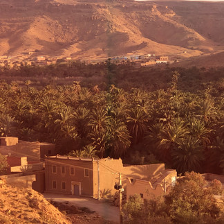
While proceeding our drive toward the rural Zaida -a small town at 1,503 m elevation in the Midelt Province, Drâa-Tafilalet,. with a Berber. Amazigh population of about 5000, the following enchanting mountainous cultivated scenery unfolded.


Timhhdite

Itzer


The other small towns, terrains, and landscape passed crossing the Atlas mountains on the bus ride, through an oasis valley toward the vast Sahara and desert's dunes
Er Rich

This Amazigh city which was founded by Sidi Ali Ashali at 1,400m above sea level, in Midelt Province, Drâa-Tafilalet Region, is of about 28,000 people.
It originally developed around a ksar, where a notorious Tazmamart prison once stood,

It was an important fortress in previous times on a river bank of Oued Ziz on the plains between the mountains,
Its geographical location is one of the most important territorial characteristics that holds the most potential in terms of tourism, trade and services, due to its. base in the oasis area of the Ziz Valley
Once there was also a small church and a synagogue; in Er-Rich. The latter had been in use till the end of the 60th when the Jewish community, that had their own school adjacent to the town's elementary school, started leaving the town.
The rabbi made the daily trip to the local slaughter house to ensure the meat was kosher
Er-Rich is a gateway to the town of Imilchil, near which the annual Bride Market takes place. and the thermal springs of El Hammat are and which attracts many Moroccan visitors for their health benefits, It lie some 22 kilometers south east of the town. Rich that Mula Ismail came from
Zaida

A small town of about 5000 inhabitants
in Midelt Province, Drâa-Tafilalet


Midelt
Coming from the north, the landscape offers some breathtaking views.
Situated in the high plains between the Middle Atlas and High Atlas surrounding the Moulouya River, and with a
population of of about 56,000


An apple country, Midelt serves as the commercial center of a large agricultural hinterland and It is also one of Morocco's principal cities for the mining of several minerals. ( lead, gypsum and other minerals.) and being known for its fossils and rocks.
It consists of little more than one main street (Ave Mohammed V in the north, which becomes Ave Hassan II to the south), a modest Souq/market and a number of oversized hotel-restaurants, which cater to the tourist buses whistling through on their way south.
The town itself is of little interest to tourists, but it makes a good base for some off-piste exploring of the Jebel Ayachi region. (more)
Sidi Ayad where we had lunch at the Hotel Taddart


The scenery on the continued bus ride


Gueres Tiaallaline - elevation 1384m

Lkheng -elevation 1011m


Rio Ziz - River Ziz
The Ziz River is a river in the south of Morocco and Algeria. It has its source in the High Atlas mountains of Morocco and flows 282 kilometers into the Sahara Desert in Algeria

Barrage Al-Hassan Addakhil - Lake/Reservoir and Dam

The Hassan Addakhil dam is situated at Foum Rhour on the Ziz river, about 10km from Errachidia city of Tafilalet province.
The Al Hassan Addakhil reservoir and its hypnotizing turquoise shining lake with its moonlike looking rock border , is fed by the Ziz River.


The purpose of the dam is to regularize the wadi in order to carry out the Ziz valley agricultural and Tafilalet lands development, as well as to provide flood protection.
The name -al-Hassan al-Dakhil - "the one who entered"- was the grandfather of Sharif ibn Ali the founder of the 'Alawid dynasty, which is the current Moroccan royal family.
Construction work on the dam was conducted from 1968 to 1971, and filling of the reservoir took place during 1970. After filling began, significant leakage flow was observed downstream, in particular at the auxiliary dam (saddle dam) ‘C’.


Valley of Ziz

National Route # 13 is a fantastic way to explore the valley.. It connects Midelt and Erfoud, and runs for more than 200 km along the Ziz River, which its water is provided from the melted snow of the Atlas mountains and which also offers breathtaking landscapes: mountains, limestone cliffs, green spots, monuments, and gorges
Starting just south of the Middle Atlas town of Rich and about 30km north of Errachidia, the tremendous Ziz Gorges provide a rocky passage south through the Tunnel du Légionnaire -built by the French in 1928 (more)
The landscapes take on a “Western movie” look in some places, evoking the Colorado Plateau and Arizona’s Grand Canyon.

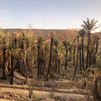
To the south, the valley widens, and offers a spectacular sight: of a dense palm groves (thousands of them) between striated cliffs, which dates to the Jurassic period.
In addition to palm trees, the fields grow other crops, such as fruit trees, cumin, grains, alfalfa, and vegetables…
The contrasts between the greenery of exquisite gardens, and the rocky walls falling sharply along the gorges is stunning.


The largest towns in the region Errachidia,, and Ouarzazate, are linked together by National Route 10. The Draa valley is served by National Route 9 which also links Ouarzazate with Marrakesh to the northwest. National Route 13 runs along the Ziz valley and links Errachidia with Meknes to the north.Ouarzazate
Cities along the Ziz river also include Erfoud and Sijilmassa. .
There is a dam with hydroelectric generating capacity on the Ziz near Errachidia

Oasis of Tafilalet
largest Saharan oasis comprised of the fortified villages of Erfoud, Arab Sebbah du Ziz, Rissani, Seffalat, Aoufous, and Jorf, together with palm groves stretching 30 miles (50 km) along the Wadi Ziz

Aoufous
A town in Errachidia Province,of about 1500 inhabitants, located near the Aoufous Formation, which bears dinosaur fossils dating back to the Cenomanian, Late Cretaceous.


Traditional arts and crafts such as the pottery of Tamegroute and the rugs of Taznakht are also significant to the local economy.[
The "Gates of Sahara" - Erfoud - A film Set Town

Erfoud - an oasis and agricultural center of about 30,000 people benefits from the water of the Ziz River.
Due to the beauty of its surrounding Sahara Desert and the town's oasis areas, Erfoud has been a filming location for many films.

The oasis town in the Sahara Desert, in the Eastern Drâa-Tafilalet region, belongs to
ait atta tribe, .


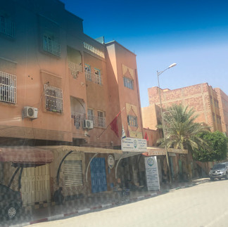


Due to its proximity to Merzouga desert village in the Erg Chebbi Dunes, Erfoud has developed tourist-related infrastructures such as hotels and restaurants.
The town is dotted with ksars -ancient fortified villages- the largest one being Maadid, of bustling streets and quaint houses.


Scenic sand and dunes have been the setting for many Hollywood adventure movies..
The film-making industry is concentrated in the Ouarzazate area
Serene desert, striking greenery and fertility of nearby oases and precious mineral fossils on the road to Merzouga. and traditional Moroccan market at Erfoud’s Souq where Berber handicrafts or fresh dates and olives. can be found, are which makes the town a tourist attraction.
Royal Palace nearby, which is famous as the only castle in the Sahara Desert, and the Bur-Est hilltop which offers picturesque views of the town below, are all worth seeing.
Fossils dating back hundreds of millions of years (see next post of 4/15) and
Oct. Dates Festival, with dancing and music are also main attraction to this town
This area of Morocco has also been identified as being very similar in appearance and possibly geology to certain areas on the planet Mars. Because of this, there is an interest in this area as a field research location for Mars analogue research.
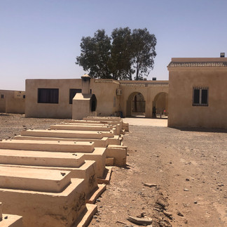
Erfoud Jewish History
Jews lived in the Erfoud region for millennia, sustaining learned rabbis in up to seven synagogues. There was no mellah in Erfoud. Jews and Muslims lived together in the medina. In 1931, and up yo 1960 the Jewish population of Erfoud was about 1,172.
All of them emigrated to Israel in the 1960’s.
Many were artisans and owners of various spice shops, and the town was the home to many great Rabbis and Kabbalists, including Rav Yitzchak Al-Fasi (also known as the “Rif”) (1013–1088), the Rambam (1160–1165), R’ Joseph Gikatila, and the Ohr HaChaim HaKadosh (1698–1742), whose burial sites , one of many in the remote Atlas region, are visited every year by Jewish pilgrims.

The cemetery is well preserved, and many of the tombstones’ inscriptions are readable.. It has a new synagogue to accommodate the services for visitors and tourists, especially in the month of December for the rabbi’s Hiloula, the event marking the anniversary of Abuchatzeira sage’s death.
The Moroccan Government has funded the refurbishment of the Jewish cemetery, including the construction of a shrine to Saint Rabbi Shmuel Abuhatzeira, the patriarch of a family of illustrious rabbis, including Rabbi Israel Abuhatzeira, the Baba Sali.
(The tomb of Baba Sali in Netivot, Israel, is one of the most popular pilgrimage sites for Israelis with Moroccan ancestry)


Rabbi Shmuel Abuchatzeira and his family moved to the city of Tafilalt from Israel, where Rabbi Shmuel’s son Moshe became the Rav of the city. Rabbi Moshe’s son, Yaakov, known as “Abir Yaakov,” succeeded his father as Rabbi of Tafilalt. Rabbi Yaakov’s eldest son, Moshe, became an Av Beit Din in the same city, and it was here that his son, Yisrael, the man who would become the Baba Sali, was born on Rosh Hashanah 5650 (1890).


The name Abuchatzeira was not the family’s original name. The grandfather, Rabbi Masoud, was named Elbaz. He came to Israel on a large barge or raft, and in Arabic, this is called a chatzeira, which means the owner of the raft.

It was dark when we finally arrive ,late evening, to the exotic desert's lodge's location at
Merzoug Village

The small southeastern village about 50 km from the Algerian border.is known for its proximity to Erg Chebbi - one of Morocco's several large reddish seas of dunes formed by wind-blown sand..
It is a popular destination for tourists
The dunes are not part of the Sahara Desert., which starts a few 100 kilometer across the border into Algeria.

We were due to climb these dunes hills early following morning,
Cab be read on my next post (4/15)

Hotel stayed in
Kasbah Tombouctou - Merzouga
Arfoud Road +212535577091
It onlylooks much better then
it really is.
To be Continued,,,,,,


Comments