Travel:Cappadocia, underground cities &Chiminy Caves,Turkey.Oct20-21/2022
- Oct 20, 2022
- 7 min read
Part 7 of a trip to Southeast Turkey and Cappadocia, which started on Oct 12th (Part 1), Oct. 14 (part 2) Oct 15 (part 3), Oct 16-17 (Part 4) Oct 18th (part 5) Oct 19th (part 6)
Cappadocia Region

Guzelyurt Göreme, Lake Nar, Kaymakli, Derinkuyu, Kaymaklı, Usichar, Mustafapasa
A Rainy Gloomy cold day welcomed our early morning outing, at this quint, once a Greek village, where we spent the previous night, sleeping at a Cave Hotel- one out of many which popped out, in recent years, thanks to efforts of youth initiatives to revive the area,
Guzelyurt Village- "Beautiful Home"

It was a prosperous Ottoman-Greek town also called Gelveri, specializing in farming and gold-smithing/diamond setting. Orthodox Christians Greeks lived in the area. as of the 8th BC, thus a large native Cappadocian Greek population existed in the area until the 1924 population exchange (see Cappadocian Greeks), when they were replaced with returning Turks from Thessaloniki and Kavala. Between 1924 for 14 years about 330 000 Turks from Greece moved back to Turkey and were taken care of by the Gov while the transfer of the Greeks to Greece, were not treated as well.


The person who conceived and insisted on this disastrous "Population Transfer"
was the Greek Colonal Georigios Grivas - a Cypriot patriot, who helped bring Cyprus independence in 1960. His goal which failed, was greater union with Greece, and an an entity cleansed one from Turks. The Turkish -Greek wars after partitioning of the Ottoman Empire, at the end of WWI, lasted for 4 years (1918-1922)
Turks in 1974 conquered the north part of Cyprus which became since then divided
The early morning walk throughout the village revealed, that what was a ghost village emptied-out of Greeks, is now a days, a village consisting of renovated traditional Greek stone houses, with small underground city beneath the town center, several churches converted to mosques, and a dramatic setting beneath the looming summit of :
Hasan Dağı,
Once Churches now Mosques
With the Christians gone and Muslims arrived, the great church became a mosque.


The one Church/Mosque entered is:
The church of St Gregory of Nazianzus, which was build in 385 It has been beautifully restored and work has been ongoing. The large entrance dates only from 1896.
An iron clapper which sits on the church's floor is a souvenir left from a church bell which once decorated the structure and was taken along with the expelled to Greec.


The Peaks of these 3 Volcanic Mountains dominate Cappadocia :
Mt. Hasan Mt. Erciyes Mt. Melensiz
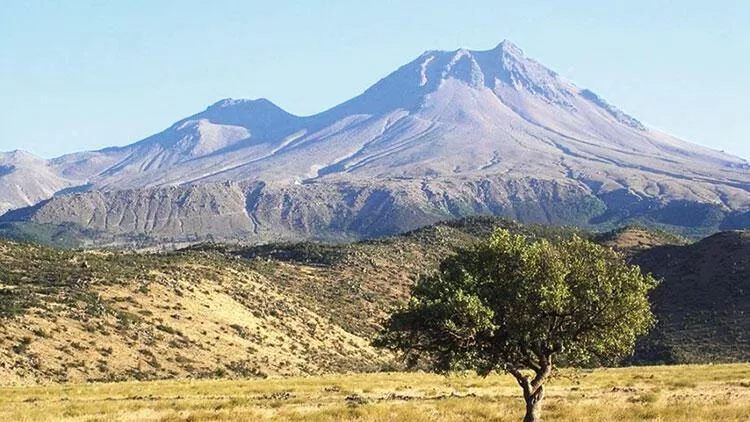


Mt Hasan's past volcanic eruptions, (30 millions years ago) along with the 2 other volcanic mountains, Mt. Erciyas and Mt, Melandiz, provided plenty of fertile Tufa soil, for great agriculture farming. and the soft rocky colorful ingredients to create most enchanting the area's geological formation landscape
The overshadowing Mountain consists of various volcanic colorful deposits, including several calderas, and its activity has been related to the presence of several faults in the area and to regional tectonics.
The Farming population in Turkey which consist of 60% benefit from the vast fertile Anatolian farm land in the country, and is also the one that extend its full political support to President Erdugan.
More on Cappadoccia Region

This ancient region, situated on the rugged plateau north of the Taurus Mountains, in Central Anatolia plains, as if plucked from a whimsical fairy tail,
consists of geological landscape of honeycombed hills, towering boulders and sub terrain hide-outs tunnel complexes, Fairy Chimney and Mushroom top Caves formations, also matched by human history from the Byzantine and Islamic era, which left the countryside, scattered with fascinating cavern architecture, underworld cities shelters, rock-cut monasteries, and churches, also decorated by unique carving and fantastic fresco paintings art, preserved on the region's colorful Tufa soft stone walls.

The dramatic expanses of the soft volcanic rock, were shaped by erosion thanks to the Red - Gizilimak River, that flow through the formatted Limestone some Granite rock, along with rain and wind into towers, cones, valleys, and caves. about 1000 above sea level Neolithic pottery and tools attest to an early human presence, as well as clay tablets remains indicate of an Hittite-Assyrian colony, dating from the 3rd millennium BC
Persian satrapy and Zoroastrian temple cults were widespread.in 6thBC when the name of Cappadocia appears at its earliest. Its ruling borders changes with the various historical many conquest. (more on the origin of the name)
The fresco-adorned churches of Göreme Open-Air Museum, and the subterranean refuges of Derinkuyu and Kaymaklı are the most famous sights, which we also viisted


Lake Nar - A volcanic Crater Lake


On the way to the more attractive Cappadocia's sites, the bus stopped by wayside at: NarLigol Thermal Spa Hotel,
next to the small volcanic geothermal
It is situated at :1,363 m altitude, on the road from Derinkuyu to Aksaray, with many hot springs around it. of 65 °C


Kaymakli Underground City This largest underground settlement in the region is under a great hill named the Citadel of Kaymaklı
The purpose of these subterranean cities was to protect the inhabitants from foreign invasion, allowing thousands of people to live their lives in total secrecy by number of the many storage rooms.
This underground city, built in the volcanic soft rock is assumed to be built first by Cappadocian Greek.(8th-7th BC) and was greatly expanded and deepened in the Eastern Roman (Byzantine) era, when it was used for protection from MuslimArab raids during the four centuries of Arab–Byzantine wars (780–1180).


After the region fell to the Seljuk Turks the caves were used as refuges from the Turkish Muslim rulers and later, during the 14th C the caves provided Christians with a safe haven from the threat of the Mongolians as well as were being used to escape periodic waves of Ottoman persecutions.
The trinket market at the entrance to the site


The city was connected with Derinkuyu underground city through miles of tunnels.
The houses in the village are constructed around the nearly one hundred tunnels of the underground city. The lower, narrower, and more steeply inclined. tunnels are still used today as storage areas, stables, and cellars.
Completely abandoned in the 1920 they were not rediscovered until 1963 and opened
to visitors in 1964 with only 4 floors uncovered,
The underground tunnels were so packed with visitors, dense and claustrophobic, at the hour we visited, that touring, just the first level, was more the enough for me as apparently was for half of the group that preferred to hang up at the street level's coffee and trinket's shops ,

Derinkuyu another Underground City
Anothr famous underground city, Derinkuyu, was built during the Byzantine era, when its inhabitants used it to protect themselves from Muslim Arabs during the Arab-Byzantine wars between 780 and 1180 CE. The multi-level city was composed of many passages and caves extending to a depth of approximately 85 m under the ground and was able to shelter around 20,000 people as well as their livestock and food. It’s certainly the deepest underground city in Cappadocia (and in all of Turkey). Derinkuyu was opened to visitors in 1969 – albeit, with only half of the city available for viewing.
More enchanting Views on the way to Usichar Site


Ucishar Village - 'Outer Citadel'
Situated on the edge of Göreme National Park, the old village is huddled around the base of a huge rock cone and the new one id closer to the road that runs toward the town to Göreme.


Like most of Cappadocia, Uçhisar once made a living from agriculture but now depends almost entirely on tourism, with many of its fine old stone houses turned into boutique hotels. French incomers and Turks returning from France have played a large part in the move to convert the houses into hotels.


Three Beauties Chimenys
The Three fairy chimneys - most enchanting famous natural beauty are amazing natural formation located on Urgüp,

The Legend's name Three Beauties was given to the fairy chimney resembling
two adults and a child.
It is based on a story about a king and beautiful princess lived in Cappadocia.

The princess, the daughter of the king, fell in love with a shepherd. however the king couldn't give his consent to this love.Realizing that she can not convince her father, the princess runs away with her beloved Shepard one night to whom she conceived a child.
Thus the Three Beauties, whom are thought to be symbolizing the family, were believed that the families without children would come here and have children by going up and down the slope, next to these fairy chimneys 7 times


Lunch places sampled
Sedef Steak & Kabab in Gureme

Caldera Hotel in Usichar

Mustafaoasa Village This quaint village in the heart of Cappadocia, where we stated 2 nights was previously called Sinasos meaning the "The City of the Sun" is of 1,300 inhabitants.
It has a unique view of its stone buildings on the margins of 5 surrounding hills, an open-air museum, to various civilizations which left important examples of civil architecture like churches, mosques and stone houses with carved and ornamented facades, showcasing the scenery of the region shaped by its topography and climate. Due to its outstanding cultural and historical heritage and location on crossroads, Mustafapaşa has always been an attraction for visitors Dinner at Old Greek House

Old Greek House Restaurant
is located in Mustafapasa.Village
The House was built in the 1800's and the first owner was a Greek artist named Yorha Vasil.
The house was sold to the Ozturk family in 1938. which used it thier as home. It was by pure chance that in 1992, When the famiy became involved in the restaurant and hospitality business they converted the Old Greek House into a restaurant and it soon became one of the most celebrated and famous restaurants in Cappadocia.
Hotel we stayed at for 2 nights

Ajwa Hotels in Mustafapasa Koyu
Yeni Mahalle Urgup Caddesi #13 /Nevsehir
+90 384352 12 12 info@cappadocia
The Ajwa resort occupies a vast tract of land with beautiful landscaped grounds
This fabulous luxury hotel opened just a year ago, at the end=tail of the Corona pandemic, and in the midst of a cavernous landscape in the beautiful historic village of Mustafapasa

Beautiful high end decorated rooms, cozy public spaces and iconic 10 cave suites, follow the Seljuke and Ottoman architecture features. Handcrafted Syrian mother of Pearl furniture, traditional hand made Azerbaijan rugs and carpets of top quality is the standard decor


Great restaurant - Zafran, pool, spa, kids club a small farm and lush garden, all promises a great family retreat vacation.
On our last day a special tour of the largest most luxurious elegant suite inside a natural a huge cave formation, designed to perfection was offered.
The 3 bedrooms,, office space, private Hamaam, and dinning room, amazingly furnished, was just opened for use recently, and promises a fabulous costly experience, if one don’t mind the absence of windows, or lack of daylight or dark night, awareness.

The morning walk through the charming small narrow canyon between tall steep rock walls, which is adjacent to the hotel, but is a public land, is now composed of mainly ruined rocks, abandoned cave houses, and remains of an historic Byzantine cave church, just recently found, which seemed to be repainted, was once a lively place.
To be continued....


Comments