Travel:Antarctica, South Shetland Il. Nov. 3-6/2025
- Nov 6, 2025
- 8 min read
Updated: Dec 24, 2025
/6
A continuation of a trip to Antarctica and other parts of Chile which includes posts from Oct 22nd -Nov 23rd


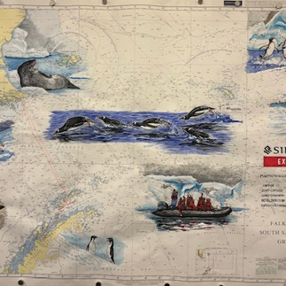

The 2 extra days added to the cruise due to the polar blizzard (see previous post), navigated from the Gerlashe Channel , back to South Shetland Islands
a group of Antarctic islands located in the Drake Passage
They lie about 120 km north of the Antarctic Peninsula.

The South Shetland Islands are special as Antarctica's "gateway," offering on the way into Antarctica, an incredible wildlife (penguins, seals, whales), rich whaling/exploration history (Shackleton's refuge), unique volcanic geology (Deception Island's caldera), and the warmest Antarctic climate.
All these make the islands the first stop after the Drake Passage
But now, the islands zone served for us as a "refuge" and the cruise's "exit gate" back to civilization. once the weather conditions would permit, a safe crossing voyage,
back to Port Williams.
The ship needed to sail slowly 10 knots speed in that zone

Grey sky and colder weather -3c with 30 -50 wind knots welcomed the day


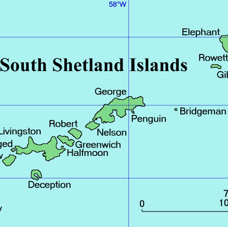


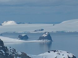
The Silver Wind was sailing through the Bransfield Strait or Fleet Sea - a body of water about 100 km wide extending for 485 km in a general northeast – southwest direction between the South Shetland Islands and the Antarctic Peninsula.
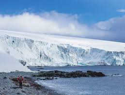
Snowy Glacial Peaks accompanied the Bransfield Starit's Perimeters


The morning landing's plan for Robert Point was aborted due to unfavorable sea water swell, which made it unsafe for disembarking onto the ship's exit platform, nor landing onto the island.
Robert Point

Robert Point is a rocky point at the end of a small peninsula projecting 2.7 km into Bransfield Strait in the South Shetland Islands,
The point is an ice-free volcanic promontory located Southeast of Robert Island which is covered by a permanent ice cap. The Point is about 1km long and 1km wide
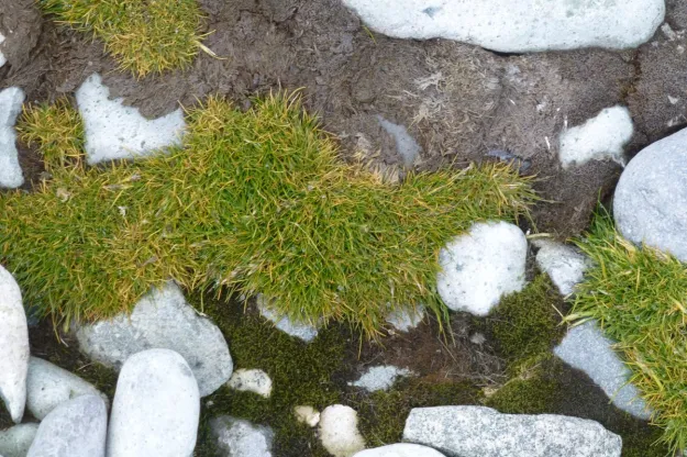
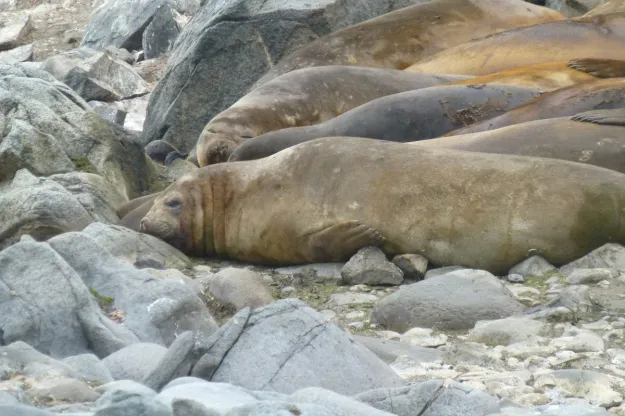
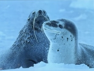
Elephant seals, Fur Seals, Chinstrap penguins, Giant Petrels, scenery glacier, mountain, other wild life and miraculously some grass, which we obviously didn't see inhabit the point


The Globe's Map of Tectonic Plates , Volcanic Geological, Formations

200 million years of subduction, rifting and continental break-up
Antarctica's Volcanic Geology is characterized by a long history of diverse volcanic activity, including large-scale volcanism during the
breakup of Gondwana - was a massive super-continent that included present-day Antarctica, South America, Africa, Australia, India, and Madagascar, centered around the South Pole, existing from roughly 600 to 180 million years ago before breaking apart due to plate tectonics, leaving Antarctica isolated and eventually covered in ice, though fossils of its shared past, like ancient trees and reptiles, still link its remnants today.
and due to persistent volcanic and significant recent activity from the West Antarctic Rift System.

This makeup includes the largest in the world, Glaciov-ulcanism activity, numerous active volcanoes, some subglacial, and is largely defined by basaltic and alkaline volcanism, with an overall composition ranging from basalt to phonolite.

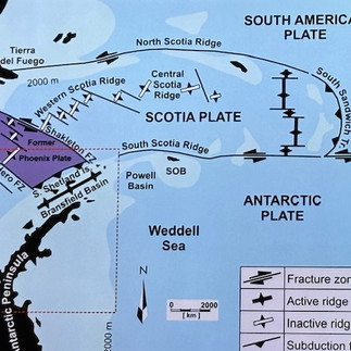


The Antarctic peninsula mountains are extension of the Chilean Andie mountains
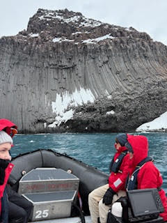
Afternoon Zodiac Excursion.
The weather reverted back to its natural arctic grey, windy very cold. with a high swell


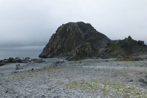
The narrow point projecting 650 m from the east coast is known for its unusual volcanic
.rock protrusion at the headland on the Varna Peninsula off Livingston Island in the South Shetland Islands.


Named after the city of Edinburgh, Scotland, the conspicuous rocky hill of 180m in elevation, is an incredible example of hexagonally-shaped columnar basalt jutting out of the sea. It seemed to be a natural polar version of a Italian leaning Pizza Tower..
The hill was photographed by Ferguson (1913-14) & visited by early 19th C by sealers.


The hill is surrounded by the freezing water's bay and at it's edge and the pointy snow caped mountains and glaciers are majestically towering it

Few penguins and seals next to each other, were observed on a icy narrow land bridge connecting 2 hilly rocks.
Zodiac's Malfunctioning incident
The ocean's swell, upon embarking into the zodiacs, was the highest, we experienced so far, when disembarking into this rubber boat, Thus the zodiac ride, was also bumpy and extremely unpleasant, To add more "insult to the injury", the steering wheel of the zodiac, we were in, malfunctioned on the way back toward the cruise ship,
Thus in addition to the usual 75 minutes of the outdoors polar exploration, during which
I was, already more than was eager to be back fast inside the ship, the "rescue operation" extended the time, staying in the polar bumpy freezing ocean outdoors.
No "emergency triple AAA" I wished for, arrived instantly..... However, another functioning zodiac replacement can always be assured, and did arrive relatively fast.
There are at least 3-4 extra vacant rescue zodiacs, in the water, at all times during the outdoors explorations.
The "acrobatic "transfer, of all 10 of us, from the malfunctioning zodiac into the rescue one, was done in the middle of the open icy wavy water. That was quite a scary experience, yet all the brave voyagers, succeeded gliding smoothly into the functioning zodiac, with no any "casualties" ending down in the water...
I was enormously relieved to be back on the dry warm safe ship, and felt merciful toward the remaining voyagers who , were just returning from the bumpy freezing ride, while subjected to even reinforced higher swell, combined with a snow fall and freezing temperate. Many returned that afternoon soaking wet from the splashing freezing water.
Heading to Baily Head


Baily Head is a prominent exposed rocky headland , 160 m high, forming the easternmost extremity of Deception Island,- a flooded caldera which makes a remarkable natural harbor,
Baily Head itself is on the eastern outer flank of the cone. situated in the South Shetland Islands


Navigating the Ship through the Narrow opening into the Caldera


Nov 4, - Anchorage at Bailey's Head of Deception Island


The South Shetland Islands off the Antarctic Peninsula. is a top of the cone caldera of an active shield volcano that last erupted in 1969
This flooded caldera - a natural bowl in the landscape, makes a remarkable natural harbor,. with a long rocky beach leading up to a curving ridge above.
To the north is an impressive glacier.
The island, roughly circular and horseshoe-shaped, with a maximum diameter around 15 km
The large and usually "safe" natural harbor,

is covered with volcanic ash layers which is occasionally affected by the underlying active volcano, It seriously damaged local scientific stations in 1967 and 1969.
The outer coast's walls of the island are characterized by 30–70 m cliffs of rock or ice and its peaks are caped with snow.
Over half (57%) of the island is covered by glaciers up to 10 m thick, ice-cored moraines, or ice-covered pyroclasts
The island Previously held a Whaling Station.


Luckily another bright sunny yet freezing weather welcomed this last day of zodiac adventure.
However the original plan of zodiac landing was reverted to zodiac exploration of Baily's Head, as the ocean swell was too high for safe beach landing.

Brown Bluff Volcano Rock formation of
distinctive “tabletop” look
A basalt tuya on northern Antarctica formed in the last 1 million years as a result of subglacial eruptions
A volcano that has been flattened by erupting through a glacier! These are the rarest of all volcano types and only found in areas that have seen large-scale glaciation in the past.
The landing beach here is made of pebbles and volcanic ash, rising quickly towards steep reddish-brown cliffs. The cliffs are embedded with “volcanic bombs” - large pieces of lava that were thrown out during an eruption, cooling in the air to land as solid spherical or oval shapes.
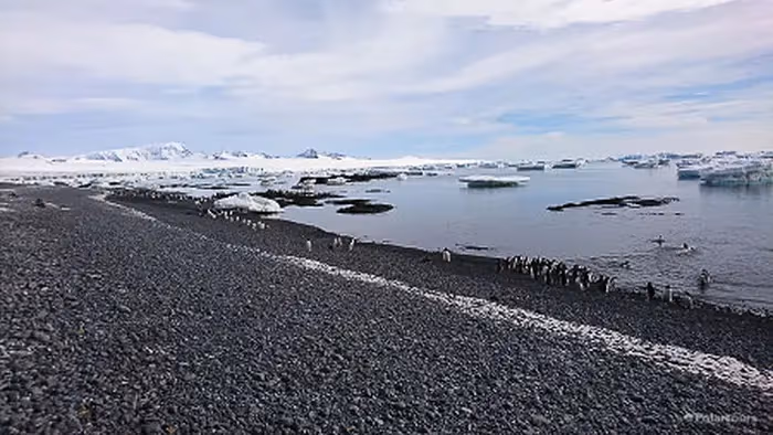


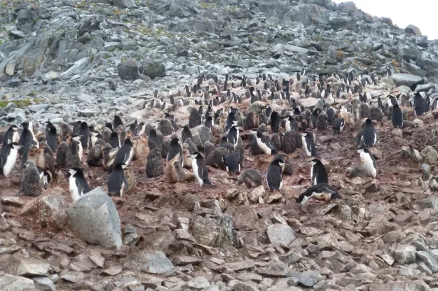
The area is home to over 20,000 breeding pairs of Adelie penguins, as well as a small colony of Gentro penguins


Neptune's Bellows Passage

The bay's narrow entrance, where the zodiac landed later in the afternoon is named Neptune's Bellows
Silver Wind sailed into the volcanic caldera, Deception Island is one of the few places where ships can sail into an active volcano's flooded caldera through the narrow passage .
The Deception Island Caldera is only one out of 5 on the entire planet where ships can sail directly into the center of a submerged caldera.
Deception Island, and the caldera at Santorini, Greece. are most noted.
Neptune's Bellows - Last zodiac Landing

The small 500m-wide slit which appeared in the cliffs of the island's south-eastern corner, allowed an entry.
Just inside Neptune's Bellows lies the cove Whalers Bay, which is bordered by a large black sand beach. Several maars line the inside rim of the caldera,


Being Welcomed by the Penguins


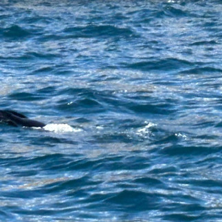
Flying above were skuas, petrels, and sheathbills. Antarctic Fur Seals and leopard seals. could be seen in the surrounding waters .right by the zodiacs


Porpoising Penguins
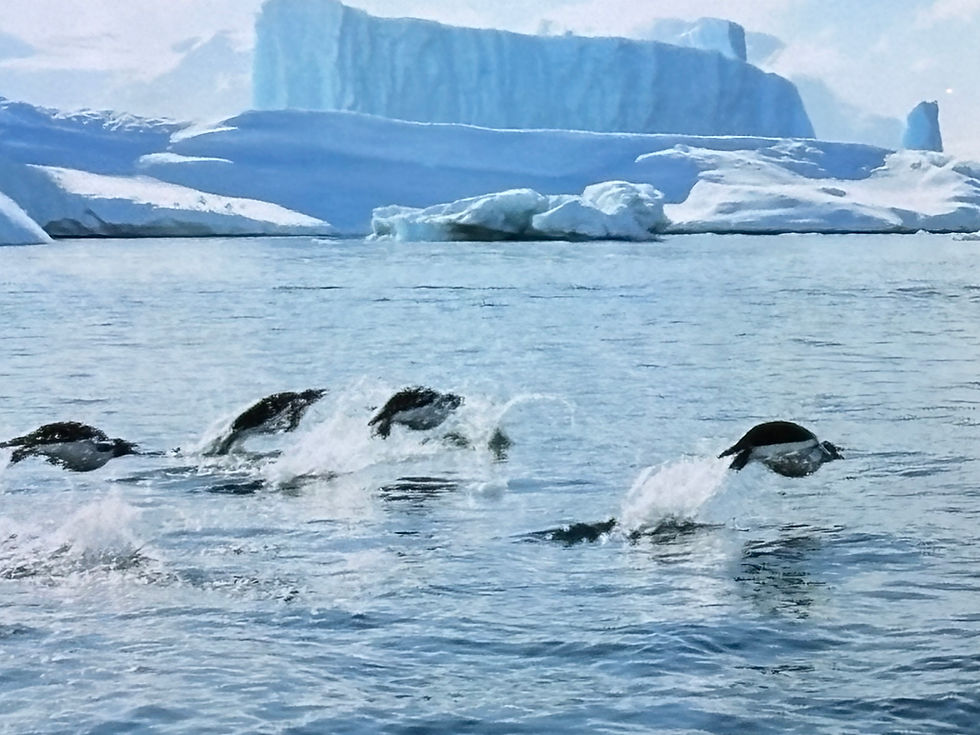


Deception Il served as the short-lived fur-sealing industry in the South Shetlands beginning with a handful of ships in the 1819–1820 summer season
The second phase of human activity at Deception Il. began in the early 20th c In 1904, with an active whaling industry being established

Several hundred men resident at Deception during the Antarctic summers and with as many as 13 ships operating in peak years.


A cemetery, the largest in Antarctica, (graves for 35 men along with a memorial to 10 more presumed drowned) was built in 1908, a radio station in 1912, a hand-operated railway also in 1912, and a small permanent magistrate's house in 1914.

Factory ships of the period were only able to strip the blubber from whales and could not use the carcasses, A permanent on-shore station was established by the Norwegian company Hvalfangerselskabet Hektor A/S in 1912
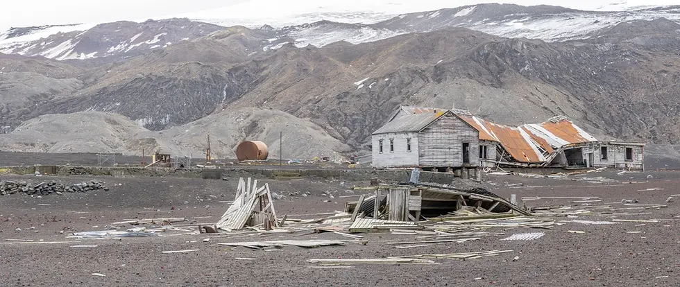
Remains of previous structures at Whalers Bay include rusting boilers and tanks, and an aircraft hangar


The volcano eruptions in 1967 and 1969, destroyed an existing scientific stations which also was established. on the Il.
Both British and Chilean stations were demolished, and the island was again abandoned for several years.
The first commercial cruise ship arrived in January 1966. By 1999, over 10,000 tourists had visited the island
Amazing Finalle Banquet

On the last evening before heading through the Drake channel crossing, back to Port Williams, an amazing creative banquet was set at dinner time


Further more after dinner the talented cruise Staff put out up an enjoyable entertainment Performance
Werner - the head of the Expedition Team gave his version of "Dirty dancing"
with his wife.

The Silver -Wind sailed relatively smoothly, all through Nov. 4th and 5th , arriving back to Port Williams in the morning of Nov 6th.
The 3-4 m wave swell on the way back was tolerable, and the great presentations given on board by the expert staff, n between packing, was a blessed distraction.

Encountering again in full view, the verdant landscape of Navarino Island with the colorful houses of Port Williams, (see post) after sailing for 12 days through the Arctic seas (see the Antarctica posts) after crossing twice-there and back- the rough water of the Drake Passage, while being immersed only in desolated monochromatic white glacial dessert scenery, was a great relief


Bye Bye Silver Wind, and many thanks to its the great Expedition Staff, and to all the wonderful adventurous people we met and befriended on the cruise.
The following few next weeks we would explore Chile on our own (see next posts)
To be continued...


Comments